This route starts from the village of Perloz and reaches Tour d’Héréraz passing through the Moretta bridge, through places of the history of the community and its lords: the Vallaise family.
It is a circular itinerary that passes through some of the most characteristic villages of Perloz perched on the mountain at the entrance to the Lys Valley.
The route winds through dense chestnut woods and terraces supported by dry stone walls built over the centuries to reclaim arable land from the mountain.
The rural architecture of the villages reflects the life of a bygone age.
The spaces for agro-pastoral activities and those for daily life were brought together in a single building spread over four levels.
This itinerary, made up of paths and mule tracks built in ancient times, is accessible almost all year round thanks to the excellent exposure to the sun and the favorable microclimate.
The botanical-landscape route begins at the entrance to the mule track for Pessé at Fey Dessous (1,100 m) to reach the Fenêtre Pass (1,673 m) after about 2 hours.
Going up the stone steps of this very ancient mule track it is possible to come across the spectacular flowering of the Laburnum which turns the whole slope yellow.
Arriving at the first houses, the gaze embraces the whole basin with its wonderful flowery meadows, the Pessé, the larch and beech woods and the “Col Fenêtre”.
The route then continues among the characteristic rural stone houses and some “Rascards” to then climbs towards the hill among numerous botanical varieties, many of which are rare and protected, until it reaches the SCI area and Col Fenêtre.
Some explanatory panels about the local flora, fauna, history and architecture are positioned along the route.
Those who want to extend the hike can continue for another hour and reach the Croix-Corma Peak (1,968 m), an excellent panoramic point over the Canavese area.
The territory of Perloz is crossed by some stages of the Cammino Balteo (Balteo Trail).
The path of stage 1, which starts from Pont-Saint-Martin, goes up towards Perloz passing in front of the Sanctuary of Notre-Dame-de-La-Garde.
The path then continues up to the village where it is possible to admire the Charles and Vallaise Castles, the wine press and the Church.
Further down, there is the Moretta bridge, famous for its gorges, the Hérères Tower and then continues towards Lillianes.
The path of stage 3 returning from the territories of Fontainemore and Lillianes reaches Chemp, an hamlet and open-air museum.
The next stop is the village of Marine with its “L’école d’autrefois” museum and the Aurora Bell.
The itinerary then turns towards the village of Perloz, the sanctuary of Notre Dame de la Garde and finally towards Donnas.
A part of the “Alta Via 1” itinerary crosses the Municipality of Perloz.
From Donnas, continuing along suggestive mule tracks, the sanctuary of Notre-Dame-de-La-Garde appears before reaching the village of Perloz.
Then go downhill towards Ponte Moretta to continue towards Lillianes.
In this stage of the “Sentieri del Lys” there is a chance to experience a lot of history: from the sanctuary of Notre-Dame-De-La-Garde to the village of Perloz with its two castles.
The Moretta bridge, built between two walls over the Lys stream, leads to the Hérères tower.
Then go up the steep slopes of the mountain towards Lillianes where man, in order to cultivate the little necessary for his survival, had to build terraces supported by dry stone walls.
The trail starts from the hamlet of Fey Dessus, taking the beautiful mule track on the right that leads to the hamlet of Pessé and subsequently to the hamlet of Prà. In correspondence with this last hamlet, once you have crossed the road, continue going up the gorge of the Nantey stream up to the Pian and Ibec pastures.
The path then turns to the left until it reaches the ridge.
The direction to keep is that towards the white cross located on the peak of Mont Crabun (2710 m.).
There is a small bivouac just below the summit.
A walk through chestnut woods along the traces of the ancient “Ru”.
The “ru” are small irrigation channels, built in the Aosta Valley starting from the Middle Ages.
The water of the Ru of Marine flows from the Nantey torrent at the bottom of a narrow gorge (920 m).
The Ru is about 1 kilometer long and was built to irrigate hay meadows, chestnut groves, vegetable gardens, vineyards and orchards.
The Glacières mill, fed by its waters, is mentioned for the first time in an early 16th century deed and it is therefore probable that the canal has medieval origins.
Bold stone archways and retaining walls were built to overcome the gullies and rocky outcrops along the route.
Today the canal is largely piped to reduce maintenance and water losses.
It continues to perform the irrigation function for which it was built more than five centuries ago.
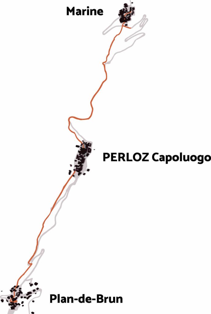
The Freedom Trail crosses the territory of Perloz, following the route of the ancient mule track which in past centuries connected the “plaine” with the Lys Valley and Fenêtre Pass.
It passes through three particularly evocative places in the context of the memory of the partisan struggle against Nazi-fascism.
Starting from the town of Plan-de-Brun, site of the first battle (March 4, 1944), after about thirty minutes, you reach the Capoluogo hamlet: several times the scene of reprisals, including the dramatic fire of June 30, 1944, one of the saddest anecdotes that happened in this area.
The route then continues, in the next half hour, towards the village of Marine, the winter headquarters of the Lys Brigade and the place where the Aurora Bell stands today, which transmits a clear invitation to peace.